07 장
MapKit, Pin Annotation
- 참고 학습자료 : http://203.237.244.98/maps.html
// ViewController.swift
// DITMap
import UIKit
import MapKit
class ViewController: UIViewController, MKMapViewDelegate {
@IBOutlet weak var myMapView: MKMapView!
override func viewDidLoad() {
super.viewDidLoad()
// Do any additional setup after loading the view, typically from a nib.
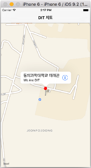
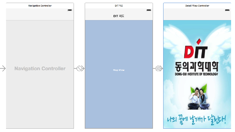
// DIT 위치정보 35.166197, 129.072594
let center = CLLocationCoordinate2DMake(35.166197, 129.072594)
let span = MKCoordinateSpanMake(0.05, 0.05)
let region = MKCoordinateRegionMake(center, span)
myMapView.setRegion(region, animated: true)
// Annotation(Pin) 꼽기
let anno01 = MKPointAnnotation()
anno01.coordinate = center
anno01.title = "DIT 동의과학대학교"
anno01.subtitle = "나의 꿈이 자라는 곳"
// 부산시민공원 35.168444, 129.057832
let anno02 = MKPointAnnotation()
anno02.coordinate.latitude = 35.168444
anno02.coordinate.longitude = 129.057832
anno02.title = "부산시민공원"
anno02.subtitle = "부산시민들의 휴식처"
myMapView.addAnnotation(anno01)
myMapView.addAnnotation(anno02)
myMapView.delegate = self
}
func mapView(_ mapView: MKMapView, viewFor annotation: MKAnnotation) -> MKAnnotationView? {
let identifier = "MyPin"
var annotationView = myMapView.dequeueReusableAnnotationView(withIdentifier: identifier) as? MKPinAnnotationView
if annotationView == nil {
annotationView = MKPinAnnotationView(annotation: annotation, reuseIdentifier: identifier)
annotationView?.canShowCallout = true
if annotation.title! == "부산시민공원" {
annotationView?.pinTintColor = UIColor.green
}
} else {
annotationView?.annotation = annotation
}
let leftIconView = UIImageView(frame: CGRect(x: 0, y: 0, width: 53, height: 53))
leftIconView.image = UIImage(named:"bright-7.png" )
annotationView?.leftCalloutAccessoryView = leftIconView
let btn = UIButton(type: .detailDisclosure)
annotationView?.rightCalloutAccessoryView = btn
return annotationView
}
func mapView(_ mapView: MKMapView, annotationView view: MKAnnotationView, calloutAccessoryControlTapped control: UIControl) {
print("callout Accessory Tapped!")
let viewAnno = view.annotation
let viewTitle: String = ((viewAnno?.title)!)!
let viewSubTitle: String = ((viewAnno?.subtitle)!)!
print("\(viewTitle) \(viewSubTitle)")
let ac = UIAlertController(title: viewTitle, message: viewSubTitle, preferredStyle: .alert)
ac.addAction(UIAlertAction(title: "OK", style: .default, handler: nil))
present(ac, animated: true, completion: nil)
}
}
소스 다운로드 : https://github.com/iOS-Lec-2017-1/Map01
CalloutAccessary Navigation

- UIViewController을 segue를 통하여 DetailViewController와 연결한다.
- rightCalloutAccessary Control 이벤트가 발생하면 performSegueWithIdentifier로 DetailViewController로 이이동한다.
//  Callout Accessary를 누르면 DetailView로 전환
    func mapView(mapView: MKMapView, annotationView view: MKAnnotationView, calloutAccessoryControlTapped control: UIControl) {

        if control == view.rightCalloutAccessoryView {
            self.performSegueWithIdentifier("GoDetail", sender: self)
        }
    }
다중 Pin Annotation
// ViewPoint.swift
import MapKit
import UIKit
class ViewPoint: NSObject, MKAnnotation {
var coordinate: CLLocationCoordinate2D
var title: String?
var subtitle: String?
init(coordinate: CLLocationCoordinate2D, title: String, subtitle: String) {
self.coordinate = coordinate
self.title = title
self.subtitle = subtitle
}
}
////////////////////////////////////////////////
// ViewController.swift
// MultiPinMap
import UIKit
import MapKit
class ViewController: UIViewController, MKMapViewDelegate {
@IBOutlet weak var myMapView: MKMapView!
override func viewDidLoad() {
super.viewDidLoad()
// Do any additional setup after loading the view, typically from a nib.
// 지도의 center, region, Map 설정
zoomToRegion()
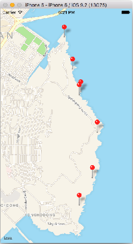
let a = ViewPoint(coordinate: CLLocationCoordinate2D(latitude: 35.104532, longitude: 129.123774), title: "오륙도 해맞이공원", subtitle: "스카이워크 걷기")
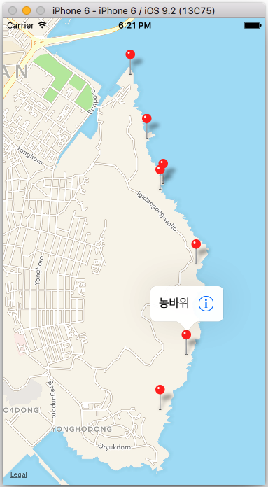
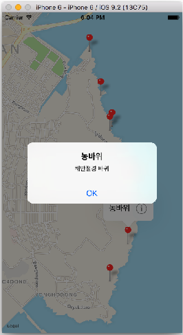
let b = ViewPoint(coordinate: CLLocationCoordinate2D(latitude: 35.109237, longitude: 129.12652), title: "농바위", subtitle: "해안절경 바위")
let c = ViewPoint(coordinate: CLLocationCoordinate2D(latitude: 35.11696, longitude: 129.12755), title: "치마바위", subtitle: "해안절경 바위")
let d = ViewPoint(coordinate: CLLocationCoordinate2D(latitude: 35.123349, longitude: 129.123774), title: "어울마당",subtitle: "광안대교가 멋진곳")
let e = ViewPoint(coordinate: CLLocationCoordinate2D(latitude: 35.12384, longitude: 129.124117), title: "해녀막사", subtitle: "해산물로 소주한잔")
let f = ViewPoint(coordinate: CLLocationCoordinate2D(latitude: 35.127701, longitude: 129.1224), title: "구름다리", subtitle: "바닷길 다리 건너기")
let g = ViewPoint(coordinate: CLLocationCoordinate2D(latitude: 35.133176, longitude: 129.120684), title: "동생말 전망대", subtitle: "광안리, 해운대 보기")
myMapView.addAnnotations([a, b, c, d, e, f, g])
myMapView.delegate = self
}
func zoomToRegion() {
let location = CLLocationCoordinate2D(latitude: 35.118002, longitude: 129.121017)
let region = MKCoordinateRegionMakeWithDistance(location, 2000.0, 4000.3)
myMapView.setRegion(region, animated: true)
}
// MKMapViewDelegate method
func mapView(_ mapView: MKMapView, viewFor annotation: MKAnnotation) -> MKAnnotationView? {
let identifier = "myPin"
// an already allocated annotation view
var annotationView = myMapView.dequeueReusableAnnotationView(withIdentifier: identifier) as? MKPinAnnotationView
if annotationView == nil {
annotationView = MKPinAnnotationView(annotation: annotation, reuseIdentifier: identifier)
annotationView?.canShowCallout = true
let btn = UIButton(type: .detailDisclosure)
annotationView?.rightCalloutAccessoryView = btn
//annotationView?.pinTintColor = UIColor.green
annotationView?.animatesDrop = true
} else {
annotationView?.annotation = annotation
}
return annotationView
}
// callout accessary를 눌렀을때 alert View 보여줌
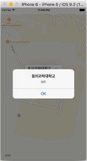
func mapView(_ mapView: MKMapView, annotationView view: MKAnnotationView, calloutAccessoryControlTapped control: UIControl) {
let viewAnno = view.annotation //as! ViewPoint
let placeName = viewAnno?.title
let placeInfo = viewAnno?.subtitle
let ac = UIAlertController(title: placeName!, message: placeInfo!, preferredStyle: .alert)
ac.addAction(UIAlertAction(title: "OK", style: .default, handler: nil))
present(ac, animated: true, completion: nil)
}
}
소스 코드 다운로드 : https://github.com/iOS-Lec-2017-1/Map_MultiPin02
plist 화일로 부터 데이터(POI 등) 불러오기
//  ViewController.swift
//  MapPinPLiist
//
//  Created by 김종현 on 2017. 9. 17..
//  Copyright © 2017년 김종현. All rights reserved.
//

import UIKit
import MapKit

class ViewController: UIViewController, MKMapViewDelegate {

    @IBOutlet weak var myMapView: MKMapView!
    override func viewDidLoad() {
        super.viewDidLoad()
        // Do any additional setup after loading the view, typically from a nib.

        zoomToRegion()

        //////////

        let path = Bundle.main.path(forResource: "ViewPoint", ofType: "plist")
        print("path = \(String(describing: path))")

        let contents = NSArray(contentsOfFile: path!)
        print("path = \(String(describing: contents))")

        var annotations = [MKPointAnnotation]()

        if let myItems = contents {
            for item in myItems {
                let lat = (item as AnyObject).value(forKey: "lat")
                let long = (item as AnyObject).value(forKey: "long")
                let title = (item as AnyObject).value(forKey: "title")
                let subTitle = (item as AnyObject).value(forKey: "subTitle")

                let annotation = MKPointAnnotation()

                print("lat = \(String(describing: lat))")

                let myLat = (lat as! NSString).doubleValue
                let myLong = (long as! NSString).doubleValue

                print("myLat = \(myLat)")

                annotation.coordinate.latitude = myLat
                annotation.coordinate.longitude = myLong
                annotation.title = title as? String
                annotation.subtitle = subTitle as? String

                annotations.append(annotation)

                myMapView.delegate = self

            }
        }

        myMapView.showAnnotations(annotations, animated: true)

    }

    func zoomToRegion() {

        //  DIT 위치정보 35.166197, 129.072594
        let center = CLLocationCoordinate2DMake(35.166197, 129.072594)
        let span = MKCoordinateSpanMake(0.05, 0.05)
        let region = MKCoordinateRegionMake(center, span)

        myMapView.setRegion(region, animated: true)

    }

    func mapView(_ mapView: MKMapView, viewFor annotation: MKAnnotation) -> MKAnnotationView? {

        let identifier = "MyPin"
        var  annotationView = myMapView.dequeueReusableAnnotationView(withIdentifier: identifier) as? MKPinAnnotationView

        if annotationView == nil {
            annotationView = MKPinAnnotationView(annotation: annotation, reuseIdentifier: identifier)
            annotationView?.canShowCallout = true

            if annotation.title! == "부산시민공원" {
                // 부시민공원
                annotationView?.pinTintColor = UIColor.green
                let leftIconView = UIImageView(frame: CGRect(x: 0, y: 0, width: 53, height: 53))
                leftIconView.image = UIImage(named:"citizen_logo.png" )
                annotationView?.leftCalloutAccessoryView = leftIconView

            } else if annotation.title! == "DIT 동의과학대학교" {
                // 동의과학대학교
                let leftIconView = UIImageView(frame: CGRect(x: 0, y: 0, width: 45, height: 45))
                leftIconView.image = UIImage(named:"DIT_logo.png" )
                annotationView?.leftCalloutAccessoryView = leftIconView

            } else {
                // 송상현광장
                annotationView?.pinTintColor = UIColor.blue
                let leftIconView = UIImageView(frame: CGRect(x: 0, y: 0, width: 45, height: 45))
                leftIconView.image = UIImage(named:"Songsang.png" )
                annotationView?.leftCalloutAccessoryView = leftIconView
            }
        } else {
            annotationView?.annotation = annotation
        }

        let btn = UIButton(type: .detailDisclosure)
        annotationView?.rightCalloutAccessoryView = btn

        return annotationView

    }

    func mapView(_ mapView: MKMapView, annotationView view: MKAnnotationView, calloutAccessoryControlTapped control: UIControl) {

        print("callout Accessory Tapped!")

        let viewAnno = view.annotation
        let viewTitle: String = ((viewAnno?.title)!)!
        let viewSubTitle: String = ((viewAnno?.subtitle)!)!

        print("\(viewTitle) \(viewSubTitle)")

        let ac = UIAlertController(title: viewTitle, message: viewSubTitle, preferredStyle: .alert)
        ac.addAction(UIAlertAction(title: "OK", style: .default, handler: nil))
        present(ac, animated: true, completion: nil)
    }

}
 소스 코드 다운로드 : https://github.com/iOS-Lec-2017-1/MapPinPList
Geocoding
CLGeocoder Class Referencehttps://developer.apple.com/library/ios/documentation/CoreLocation/Reference/CLGeocoder_class/
address.plist
//  ViewController.swift
//  MapPinPList
//  GeoCoding
//  Created by 김종현 on 2017. 9. 17..
//  Copyright © 2017년 김종현. All rights reserved.
//

import UIKit
import MapKit

class ViewController: UIViewController, MKMapViewDelegate {

    @IBOutlet weak var myMapView: MKMapView!

    //var annotations = [MKPointAnnotation]()

    override func viewDidLoad() {
        super.viewDidLoad()
        // Do any additional setup after loading the view, typically from a nib.

        zoomToRegion()

        /////////////////////////////

        let path = Bundle.main.path(forResource: "Address2", ofType: "plist")
        print("path = \(String(describing: path))")

        let contents = NSArray(contentsOfFile: path!)
        print("path = \(String(describing: contents))")

        var annotations = [MKPointAnnotation]()

         myMapView.delegate = self

        // optional binding
        if let myItems = contents {
            // Dictionary Array에서 값 뽑기
            for item in myItems {
                let address = (item as AnyObject).value(forKey: "address")
                let title = (item as AnyObject).value(forKey: "title")

                let geoCoder = CLGeocoder()

                geoCoder.geocodeAddressString(address as! String, completionHandler: { placemarks, error in

                    if error != nil {
                        print(error!)
                        return
                    }

                    if let myPlacemarks = placemarks {
                        let myPlacemark = myPlacemarks[0]

                        print("placemark[0] = \(String(describing: myPlacemark.name))")

                        let annotation = MKPointAnnotation()
                        annotation.title = title as? String
                        annotation.subtitle = address as? String

                        if let myLocation = myPlacemark.location {
                            annotation.coordinate = myLocation.coordinate
                            annotations.append(annotation)
                        }

                    }
                    print("annotations = \(annotations)")
                    self.myMapView.showAnnotations(annotations, animated: true)
                    self.myMapView.addAnnotations(annotations)

                })
            }
        } else {
            print("contents의 값은 nil")
        }

    }

    func zoomToRegion() {

        //  DIT 위치정보 35.166197, 129.072594
        let center = CLLocationCoordinate2DMake(35.166197, 129.072594)
        let span = MKCoordinateSpanMake(0.05, 0.05)
        let region = MKCoordinateRegionMake(center, span)

        myMapView.setRegion(region, animated: true)

    }

//    func mapView(_ mapView: MKMapView, viewFor annotation: MKAnnotation) -> MKAnnotationView? {
//
//        let identifier = "MyPin"
//        var  annotationView = myMapView.dequeueReusableAnnotationView(withIdentifier: identifier) as? MKPinAnnotationView
//
//        if annotationView == nil {
//            annotationView = MKPinAnnotationView(annotation: annotation, reuseIdentifier: identifier)
//            annotationView?.canShowCallout = true
//
//            if annotation.title! == "부산시민공원" {
//                // 부시민공원
//                annotationView?.pinTintColor = UIColor.green
//                let leftIconView = UIImageView(frame: CGRect(x: 0, y: 0, width: 53, height: 53))
//                leftIconView.image = UIImage(named:"citizen_logo.png" )
//                annotationView?.leftCalloutAccessoryView = leftIconView
//
//            } else if annotation.title! == "동의과학대학교" {
//                // 동의과학대학교
//                let leftIconView = UIImageView(frame: CGRect(x: 0, y: 0, width: 45, height: 45))
//                leftIconView.image = UIImage(named:"DIT_logo.png" )
//                annotationView?.leftCalloutAccessoryView = leftIconView
//
//            } else {
//                // 송상현광장
//                annotationView?.pinTintColor = UIColor.blue
//                let leftIconView = UIImageView(frame: CGRect(x: 0, y: 0, width: 45, height: 45))
//                leftIconView.image = UIImage(named:"Songsang.png" )
//                annotationView?.leftCalloutAccessoryView = leftIconView
//            }
//        } else {
//            annotationView?.annotation = annotation
//        }
//
//        let btn = UIButton(type: .detailDisclosure)
//        annotationView?.rightCalloutAccessoryView = btn
//
//        return annotationView
//
//    }
//
//    func mapView(_ mapView: MKMapView, annotationView view: MKAnnotationView, calloutAccessoryControlTapped control: UIControl) {
//
//        print("callout Accessory Tapped!")
//
//        let viewAnno = view.annotation
//        let viewTitle: String = ((viewAnno?.title)!)!
//        let viewSubTitle: String = ((viewAnno?.subtitle)!)!
//
//        print("\(viewTitle) \(viewSubTitle)")
//
//        let ac = UIAlertController(title: viewTitle, message: viewSubTitle, preferredStyle: .alert)
//        ac.addAction(UIAlertAction(title: "OK", style: .default, handler: nil))
//        present(ac, animated: true, completion: nil)
//    }

}
소스코드 다운로드
소스코드(plist, TableView) 다운로드
Overlay로 line 렌더링 하기
// ViewController.swift
// Multi-Pin Annotation & Over Line Rendering
import MapKit
import UIKit
class ViewController: UIViewController {
@IBOutlet weak var mapView: MKMapView!
override func viewDidLoad() {
super.viewDidLoad()
zoomToRegion()
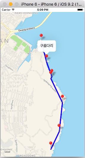
let a = ViewPoint(title: "오륙도 해맞이공원", coordinate: CLLocationCoordinate2D(latitude: 35.104532, longitude: 129.123774), info: "스카이워크 걷기")
let b = ViewPoint(title: "농바위", coordinate: CLLocationCoordinate2D(latitude: 35.109237, longitude: 129.12652), info: "해안절경 바위")
let c = ViewPoint(title: "치마바위", coordinate: CLLocationCoordinate2D(latitude: 35.11696, longitude: 129.12755), info: "해안절경 바위")
let d = ViewPoint(title: "어울마당", coordinate: CLLocationCoordinate2D(latitude: 35.123349, longitude: 129.123774), info: "광안대교가 멋진곳")
let e = ViewPoint(title: "해녀막사", coordinate: CLLocationCoordinate2D(latitude: 35.12384, longitude: 129.124117), info: "해산물로 소주한잔")
let f = ViewPoint(title: "구름다리", coordinate: CLLocationCoordinate2D(latitude: 35.127701, longitude: 129.1224), info: "바닷길 다리 건너기")
let g = ViewPoint(title: "동생말 전망대", coordinate: CLLocationCoordinate2D(latitude: 35.133176, longitude: 129.120684), info: "광안리, 해운대 보기")
let myPoint = [a, b, c, d, e, f, g]
var myCoordinate = [a.coordinate, b.coordinate, c.coordinate, d.coordinate, e.coordinate,
f.coordinate, g.coordinate]
//mapView.addAnnotations([a, b, c, d, e, f, g])
mapView.showAnnotations(myPoint, animated: true)
mapView.selectAnnotation(e, animated: true)
//////
let polyline = MKPolyline(coordinates: &myCoordinate, count: myCoordinate.count)
mapView.addOverlay(polyline)
}
func zoomToRegion() {
let location = CLLocationCoordinate2D(latitude: 35.118002, longitude: 129.121017)
let region = MKCoordinateRegionMakeWithDistance(location, 2000.0, 4000.3)
mapView.setRegion(region, animated: true)
}
func mapView(mapView: MKMapView!, viewForAnnotation annotation: MKAnnotation!) -> MKAnnotationView! {
// 1
let identifier = "MyPin"
// 사용자의 현재 위치 annotation을 제외함
if annotation.isKindOfClass(MKUserLocation) {
return nil
}
// 2
if annotation .isKindOfClass(ViewPoint) {
// if annotation is ViewPoint
// 3
var annotationView = mapView.dequeueReusableAnnotationViewWithIdentifier(identifier)
if annotationView == nil {
//4
annotationView = MKPinAnnotationView(annotation:annotation, reuseIdentifier:identifier)
annotationView!.canShowCallout = true
// // 5
// let btn = UIButton(type: .DetailDisclosure)
// annotationView!.rightCalloutAccessoryView = btn
} else {
// 6
annotationView!.annotation = annotation
}
// 5
let btn = UIButton(type: .DetailDisclosure)
annotationView!.rightCalloutAccessoryView = btn
return annotationView
}
// 7
return nil
}
func mapView(mapView: MKMapView!, annotationView view: MKAnnotationView!, calloutAccessoryControlTapped control: UIControl!) {
let viewAnno = view.annotation as! ViewPoint // MKAnnotation
let placeName = viewAnno.title
let placeInfo = viewAnno.info
let ac = UIAlertController(title: placeName, message: placeInfo, preferredStyle: .Alert)
ac.addAction(UIAlertAction(title: "OK", style: .Default, handler: nil))
presentViewController(ac, animated: true, completion: nil)
}
func mapView(mapView: MKMapView!, viewForOverlay overlay: MKOverlay!) -> MKOverlayRenderer! {
if (overlay is MKPolyline) {
let pr = MKPolylineRenderer(overlay: overlay);
pr.strokeColor = UIColor.orangeColor().colorWithAlphaComponent(0.5);
pr.lineWidth = 5;
return pr;
}
return nil
}
}
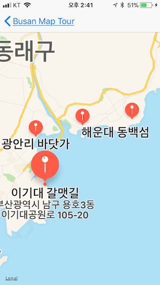
[코딩 문제] Busan Map Tour
plist 화일

storyboard
앱 스크린
//  ViewController.swift
//  PlistToTableView
//
//  Created by 김종현 on 2017. 10. 1..
//  Copyright © 2017년 김종현. All rights reserved.
//

import UIKit

class ViewController: UIViewController, UITableViewDelegate, UITableViewDataSource {

    @IBOutlet weak var myTableView: UITableView!

    var contents = NSArray()

    override func viewDidLoad() {
        super.viewDidLoad()
        // Do any additional setup after loading the view, typically from a nib.
        myTableView.delegate = self
        myTableView.dataSource = self

        self.title = "Busan Map Tour"

        // 데이터 로드
        let path = Bundle.main.path(forResource: "Address2", ofType: "plist")
        contents = NSArray(contentsOfFile: path!)!

    }


    func tableView(_ tableView: UITableView, numberOfRowsInSection section: Int) -> Int {
        return contents.count
    }

    func tableView(_ tableView: UITableView, cellForRowAt indexPath: IndexPath) -> UITableViewCell {
        let myCell = myTableView.dequeueReusableCell(withIdentifier: "myCell", for: indexPath)

        let myTitle = (contents[indexPath.row] as AnyObject).value(forKey: "title")
        let myAddress = (contents[indexPath.row] as AnyObject).value(forKey: "address")

        print(myAddress!)

        myCell.textLabel?.text = myTitle as? String
        myCell.detailTextLabel?.text = myAddress as? String

        return myCell
    }

    // 위치정보 등 데이터를 DetailMapViewController에 전달
    override func prepare(for segue: UIStoryboardSegue, sender: Any?) {
        if segue.identifier == "goDetail" {

            let detailMVC = segue.destination as! DetailMapViewController
            let selectedPath = myTableView.indexPathForSelectedRow

            let myIndexedTitle = (contents[(selectedPath?.row)!] as AnyObject).value(forKey: "title")
            let myIndexedAddress = (contents[(selectedPath?.row)!] as AnyObject).value(forKey: "address")

            print("myIndexedTitle = \(String(describing: myIndexedTitle))")

            detailMVC.dTitle = myIndexedTitle as? String
            detailMVC.dAddress = myIndexedAddress as? String

        } else if segue.identifier == "goTotalMap" {
            print("this is TotlMapViewController")

            let totalMVC = segue.destination as! TotalMapViewController
            totalMVC.dContents = contents

        }
    }

}
//  DetailMapViewController.swift
//  PlistToTableView
//
//  Created by 김종현 on 2017. 10. 6..
//  Copyright © 2017년 김종현. All rights reserved.
//

import UIKit
import MapKit

class DetailMapViewController: UIViewController {

    var dTitle: String?
    var dAddress: String?

    @IBOutlet weak var detailMapView: MKMapView!
    override func viewDidLoad() {
        super.viewDidLoad()

        // Do any additional setup after loading the view.
        print("dTitle = \(String(describing: dTitle))")
        print("dAddress = \(String(describing: dAddress))")

        // navigation title 설정
        self.title = dTitle

        // geoCoding
        let geoCoder = CLGeocoder()
        geoCoder.geocodeAddressString(dAddress!, completionHandler: { plackmarks, error in

            if error != nil {
                print(error!)
            }

            if plackmarks != nil {
                let myPlacemark  = plackmarks?[0]

                if (myPlacemark?.location) != nil {
                    let myLat = myPlacemark?.location?.coordinate.latitude
                    let myLong = myPlacemark?.location?.coordinate.longitude
                    let center = CLLocationCoordinate2DMake(myLat!, myLong!)
                    let span = MKCoordinateSpanMake(0.05, 0.05)
                    let region = MKCoordinateRegionMake(center, span)
                    self.detailMapView.setRegion(region, animated: true)

                    // Pin 꼽기, title, suttitle
                    let anno = MKPointAnnotation()
                    anno.title = self.dTitle
                    anno.subtitle = self.dAddress
                    anno.coordinate = (myPlacemark?.location?.coordinate)!
                    self.detailMapView.addAnnotation(anno)
                    self.detailMapView.selectAnnotation(anno, animated: true)
                }
            }

        } )

    }
}
//  TotalMapViewController.swift
//  PlistToTableView
//
//  Created by 김종현 on 2017. 10. 8..
//  Copyright © 2017년 김종현. All rights reserved.
//

import UIKit
import MapKit

class TotalMapViewController: UIViewController {

    @IBOutlet weak var totalMapView: MKMapView!
    var dContents: NSArray?

    override func viewDidLoad() {
        super.viewDidLoad()

        // Do any additional setup after loading the view.
        print("dContents = \(String(describing: dContents))")

        var annos = [MKPointAnnotation]()

        if let myItems = dContents {
            for item in myItems {
                let address = (item as AnyObject).value(forKey: "address")
                let title = (item as AnyObject).value(forKey: "title")
                let geoCoder = CLGeocoder()

                geoCoder.geocodeAddressString(address as! String, completionHandler: { placemarks, error in
                    if error != nil {
                        print(error!)
                        return
                    }

                    if let myPlacemarks = placemarks {
                        let myPlacemark = myPlacemarks[0]

                        let anno = MKPointAnnotation()
                        anno.title = title as? String
                        anno.subtitle = address as? String

                        if let myLocation = myPlacemark.location {
                            anno.coordinate = myLocation.coordinate
                            annos.append(anno)
                        }

                    }

                    self.totalMapView.showAnnotations(annos, animated: true)
                    self.totalMapView.addAnnotations(annos)
                } )
            }

            } else {
                print("dContents의 값은 nil")
            }

    }
}
소스 코드 : https://github.com/iOS-Lec-2017-1/PlistTableViewNaviGeocoding
CoreLocation

NSLocationAlwaysUsageDescription(항상 허용)NSLocationWhenInUseUsageDescription(사용중인 경우만 허용)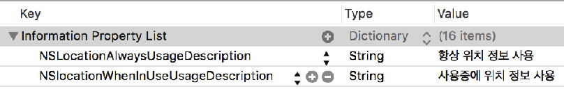
// ViewController.swift
// Simple CoreLocation Test
import UIKit
import MapKit
import CoreLocation
class ViewController: UIViewController, CLLocationManagerDelegate {
@IBOutlet var myMapView: MKMapView!
var locationManager = CLLocationManager()
override func viewDidLoad() {
super.viewDidLoad()
// Do any additional setup after loading the view, typically from
locationManager.delegate = self
locationManager.startUpdatingLocation()
locationManager.requestWhenInUseAuthorization()
locationManager.startUpdatingLocation()
locationManager.requestAlwaysAuthorization()
myMapView.showsUserLocation = true
}
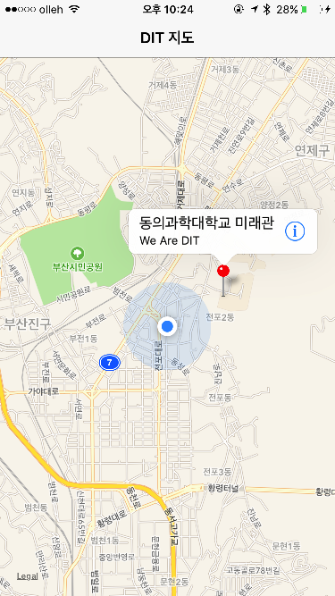
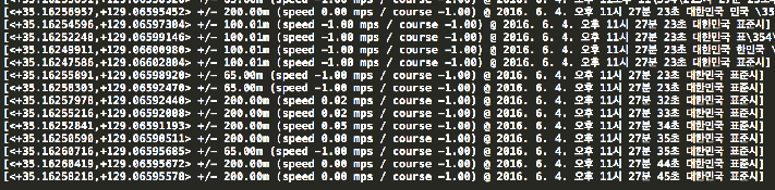
func locationManager(manager: CLLocationManager, didUpdateLocations locations: [CLLocation]) {
let userLocation: CLLocation = locations[0]
print(userLocation)
let center = CLLocationCoordinate2D(latitude: userLocation.coordinate.latitude, longitude: userLocation.coordinate.longitude)
let region = MKCoordinateRegion(center: center, span: MKCoordinateSpan(latitudeDelta: 0.03, longitudeDelta: 0.03))
myMapView.setRegion(region, animated: true)
////
let annotation = MKPointAnnotation()
annotation.coordinate = center
annotation.title = "동의과학대학교 미래관"
annotation.subtitle = "We Are DIT"
myMapView.addAnnotation(annotation)
myMapView.selectAnnotation(annotation, animated: true)
}
override func didReceiveMemoryWarning() {
super.didReceiveMemoryWarning()
// Dispose of any resources that can be recreated.
}
}
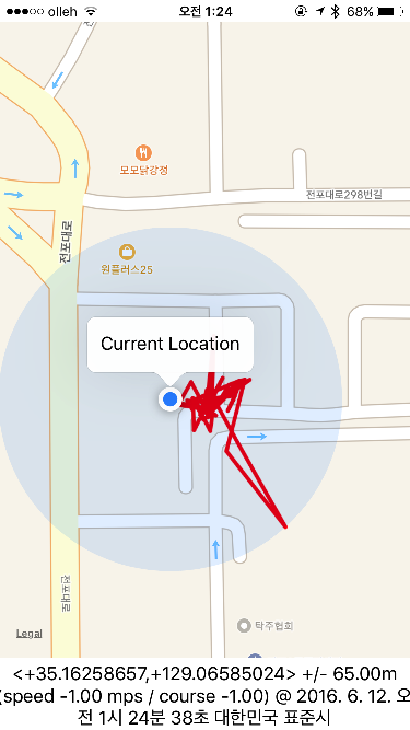
Location Tracking : Corelocation, overlay line rendering
// ViewController.swift
// Location Tracker
import UIKit
import MapKit
import CoreLocation
class ViewController: UIViewController, CLLocationManagerDelegate, MKMapViewDelegate {
@IBOutlet var mapView: MKMapView!
@IBOutlet var outLabel: UILabel!
var manager: CLLocationManager!
var myLocations: [CLLocation] = []
override func viewDidLoad() {
super.viewDidLoad()
// Do any additional setup after loading the view, typically from a nib.
// setup location manager
manager = CLLocationManager()
manager.delegate = self
manager.desiredAccuracy = kCLLocationAccuracyBest
manager.requestAlwaysAuthorization()
manager.startUpdatingLocation()
// setup MapView
mapView.delegate = self
//mapView.mapType = MKMapType.Hybrid
mapView.showsUserLocation = true
locateAndAddPin()
}
func locationManager(manager: CLLocationManager, didUpdateLocations locations: [CLLocation]) {
outLabel.text = "\(locations[0])"
myLocations.append(locations[0])
let newRegion = MKCoordinateRegion(center: mapView.userLocation.coordinate, span: MKCoordinateSpanMake(0.015, 0.015))
mapView.setRegion(newRegion, animated: true)
if myLocations.count > 1 {
let sourceIndex = myLocations.count - 1
let destinationIndex = myLocations.count - 2
let c1 = myLocations[sourceIndex].coordinate
let c2 = myLocations[destinationIndex].coordinate
print("MyLocations's count = \(myLocations.count)")
print("source Index = \(sourceIndex)")
print("dest Index = \(destinationIndex)")
var a = [c1, c2]
let polyline = MKPolyline(coordinates: &a, count: a.count)
mapView.addOverlay(polyline)
}
}
func mapView(mapView: MKMapView, rendererForOverlay overlay: MKOverlay) -> MKOverlayRenderer {
let polylineRenderer = MKPolylineRenderer(overlay: overlay)
polylineRenderer.strokeColor = UIColor.redColor()
polylineRenderer.lineWidth = 3
return polylineRenderer
}
// func mapView(mapView: MKMapView, rendererForOverlay overlay: MKOverlay) -> MKOverlayRenderer {
// let pr = MKPolylineRenderer(overlay: overlay)
// pr.strokeColor = self.lightBlue
// pr.lineWidth = 14
// return pr
// }
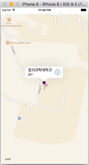
func locateAndAddPin() {
// 동의과학대학교 35.165500, 129.071274
// 위도, 경도 설정
let center: CLLocationCoordinate2D = CLLocationCoordinate2DMake(35.165500, 129.071274)
// 보여주는 범위 설정
let span = MKCoordinateSpanMake(0.015, 0.015)
// 보여주는 region 설정
let region = MKCoordinateRegionMake(center, span)
mapView.setRegion(region, animated: true)
////// annotation 꼽기
let annotation = MKPointAnnotation()
annotation.coordinate = center
annotation.title = "나의 서식처"
annotation.subtitle = " DIT"
mapView.addAnnotation(annotation)
mapView.selectAnnotation(annotation, animated: true)
}
override func didReceiveMemoryWarning() {
super.didReceiveMemoryWarning()
// Dispose of any resources that can be recreated.
}
}
참고 학습자료 : current location tracking & overlay line rendering
http://www.johnmullins.co/blog/2014/08/14/location-tracker-with-maps/
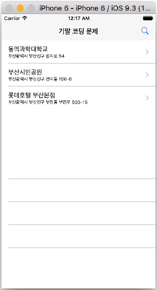
2019-2 중간고사 코딩 문제
아래의 storyboard를 참고하여 코딩하세요.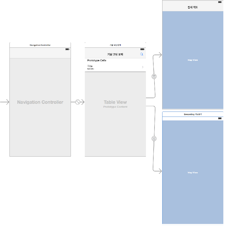
(문제 1)
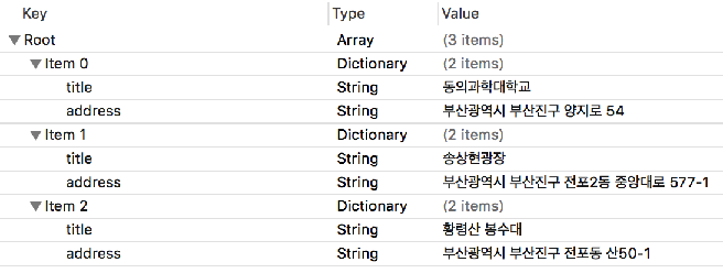
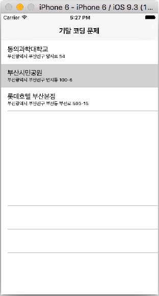
plist 화일을 작성하고, 데이터를 load하여 아래의 테이블 뷰를 만든다.
key : address, title
value :
부산광역시 부산진구 양지로 54 동의과학대학교
부산광역시 부산진구 연지동 100-6 부산시민공원
부산광역시 부사진구 부전동 부전로 503-15 롯데호텔 부산본점
(문제 2)
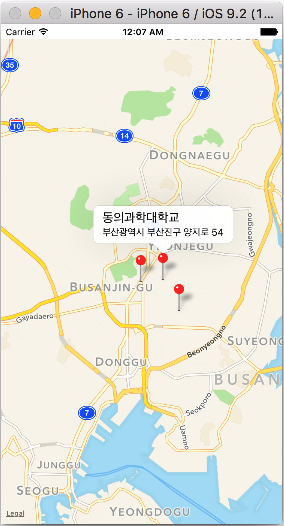
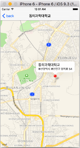
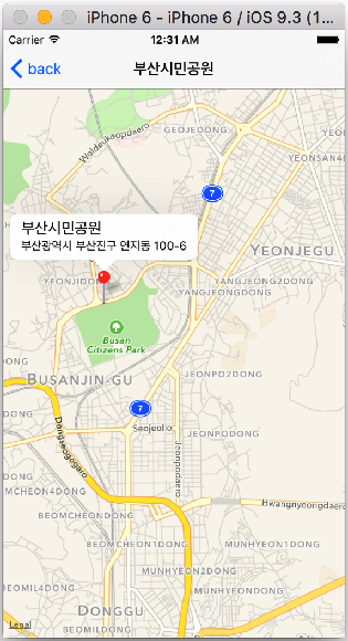
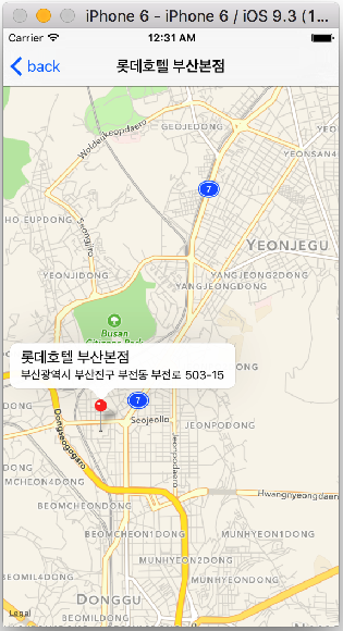
- 테이블뷰의 각 cell을 선택하면 아래와 같이 detailViewController에 지도를 표시한다.
- 이때 각 cell의 주소를 goecoding하여 지도를 표시하고, pin의 title과 subtitle을 아래와 같이 설정한다.
- NavigationBar의 title 내용도 아래와 같이 설정한다.
- 지도의 center는 latitude: 35.164472, longitude: 129.064898로 설정하라.
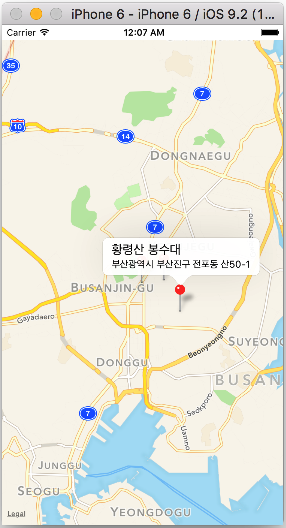
(문제 3)
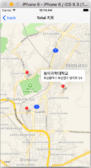
- NavigationBar의 오른쪽에 UIBarButtonItem을 이용하여 아래와 같이 System Icon(Serach)를 설정한다.
- barButtonItem Icon을 선택하면, 아래와 같이 detailViewController에 테이블뷰에 있는 모든 주소(3곳)의 지도를 아래와 같이 표시하라.
- plist 데이터를 load하여 주소를 geocoding 하여 지도와 pin을 아래와 같이 설정한다.
(문제 4)
- (문제 2)와 (문제 3)에 CoreLocation Framework을 사용하여 현재 위치(UserLocation)이 표시되고 위치정보를 tracking하도록 코딩하시오. 이때 현재 위치는 항상 지도의 center에 위치하도록 한다.